Home > Aerial Photography > Related Images
Helena Montana US City Street Map

![]()
Wall Art and Photo Gifts from Fine Art Storehouse
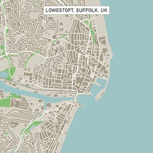
Helena Montana US City Street Map
Vector Illustration of a City Street Map of Helena, Montana, USA. Scale 1:60, 000.
All source data is in the public domain.
U.S. Geological Survey, US Topo
Used Layers:
USGS The National Map: National Hydrography Dataset (NHD)
USGS The National Map: National Transportation Dataset (NTD)
Unleash your creativity and transform your space into a visual masterpiece!
Frank Ramspott
Media ID 15054951
© Frank Ramspott, all rights reserved
Aerial View City Map Computer Graphic Directly Above Downtown District Gray Montana Road Map Text Digitally Generated Image Green Color Helena White Color
FEATURES IN THESE COLLECTIONS
> Aerial Photography
> Related Images
> Animals
> Insects
> Hemiptera
> Green Scale
> Arts
> Contemporary art
> Digital artwork
> Street art
> Arts
> Landscape paintings
> Waterfall and river artworks
> River artworks
> Arts
> Portraits
> Pop art gallery
> Street art portraits
> Arts
> Street art graffiti
> Digital art
> Digital paintings
> Arts
> Street art graffiti
> Digital art
> Vector illustrations
> Fine Art Storehouse
> Map
> Street Maps
> Fine Art Storehouse
> Map
> USA Maps
> Maps and Charts
> Geological Map
> Maps and Charts
> Related Images
> North America
> United States of America
> Lakes
> Related Images
EDITORS COMMENTS
This print showcases a meticulously detailed city street map of Helena, Montana, USA. Created as a vector illustration with a scale of 1:60,000, this artwork provides an immersive view of the city's layout and features. The artist, Frank Ramspott, skillfully utilized various layers from publicly available data sources such as the U. S. Geological Survey (USGS) to bring this map to life. The image encompasses key elements like the Berkeley Pit, downtown district, lake, river, streets, and roads that make up Helena's urban landscape. With its vibrant colors including shades of gray, blue, white and green against a backdrop of textural aerial views directly above the cityscape; this digitally generated artwork is both visually striking and informative. Ideal for enthusiasts of cartography or those with an affinity for exploring new places from the comfort of their own homes; this print offers an opportunity to appreciate the artistry behind mapping while gaining insight into Helena's physical geography. Notably absent are any human figures in order to emphasize the focus on showcasing the city itself. Frank Ramspott's creation serves as a testament to his talent in merging design principles with computer graphics resulting in a stunning representation of Helena’s urban environment. Whether displayed at home or office spaces alike; this unique piece will undoubtedly spark conversations about travel adventures or ignite curiosity about one’s surroundings.
MADE IN THE USA
Safe Shipping with 30 Day Money Back Guarantee
FREE PERSONALISATION*
We are proud to offer a range of customisation features including Personalised Captions, Color Filters and Picture Zoom Tools
SECURE PAYMENTS
We happily accept a wide range of payment options so you can pay for the things you need in the way that is most convenient for you
* Options may vary by product and licensing agreement. Zoomed Pictures can be adjusted in the Cart.