Home > Animals > Birds > Columbiformes > Doves > Related Images
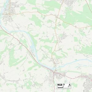
South Oxfordshire RG9 5 Map

![]()
Wall Art and Photo Gifts from Map Marketing
South Oxfordshire RG9 5 Map
Postcode Sector Map of South Oxfordshire RG9 5
Media ID 19981052
Ashdown Way Bradley Road Chapel Lane Cherry Tree Close Chiltern Road Church Lane Church View Churchfield Colliers Lane Coxs Lane Deadmans Lane Dog Lane Dove Lane Grange Avenue Gravel Hill Hatch Lane Hawthorn Drive Hazel Grove Heath End High Street Holly Close Lime Avenue Main Street Mill Road Newlands Lane Ridgeway Close School Lane South Oxfordshire Stevens Lane The Glebe The Green The Ridgeway Green Trees Nuffield
FEATURES IN THESE COLLECTIONS
> Animals
> Birds
> Columbiformes
> Doves
> Related Images
> Animals
> Mammals
> Dogs (Wild)
> Bush Dog
> Animals
> Mammals
> Muridae
> Heath Mouse
> Europe
> United Kingdom
> England
> Oxfordshire
> Grove
> Europe
> United Kingdom
> England
> Oxfordshire
> Nuffield
> Europe
> United Kingdom
> England
> Oxfordshire
> Related Images
> Europe
> United Kingdom
> England
> Oxfordshire
> Shiplake
> Europe
> United Kingdom
> England
> Oxfordshire
> South Stoke
> Europe
> United Kingdom
> England
> Oxfordshire
> Stoke Row
> Europe
> United Kingdom
> England
> Oxfordshire
> Watlington
> Map Marketing
> Postcode Sector Maps
> RG - Reading
MADE IN THE USA
Safe Shipping with 30 Day Money Back Guarantee
FREE PERSONALISATION*
We are proud to offer a range of customisation features including Personalised Captions, Color Filters and Picture Zoom Tools
SECURE PAYMENTS
We happily accept a wide range of payment options so you can pay for the things you need in the way that is most convenient for you
* Options may vary by product and licensing agreement. Zoomed Pictures can be adjusted in the Cart.