Home > Europe > United Kingdom > England > London > Towns > Mill Hill
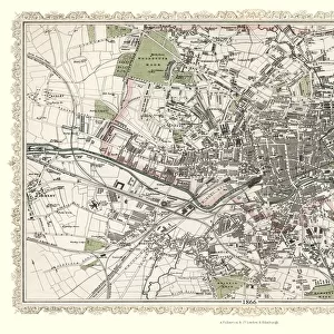
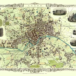
Old Map of Leeds 1851 by John Tallis

![]()
Wall Art and Photo Gifts from MapSeeker
Old Map of Leeds 1851 by John Tallis
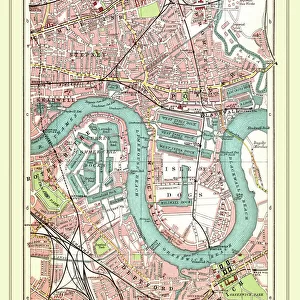
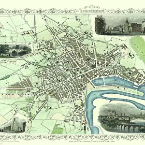
This map of Leeds in West Yorkshire by John Tallis 1851 features the districts of Woodhouse Carr, Great Woodhouse, Little London, New Town, Little Woodhouse, New Wortley, Holbeck, and Hunslet. The plan is finished with illustrations of Mill Hill Chapel, Kirkstall Abbey, Wellington Bridge, New Gaol, Woodhouse Cemetry, Town Hall and St Peters Church as well as a canal view
Welcome to the Mapseeker Image library and enter an historic gateway to one of the largest on-line collections of Historic Maps, Nostalgic Views, Vista's and Panorama's from a World gone by.
Media ID 20347580
Historic Map John Tallis John Tallis Map Old Town Plan Tallis Map Leeds
FEATURES IN THESE COLLECTIONS
> Animals
> Mammals
> Muridae
> Peters Mouse
> Arts
> Artists
> H
> John Hillers
> Arts
> Artists
> H
> John Hills
> Arts
> Artists
> T
> John Tallis
> Europe
> United Kingdom
> England
> London
> Towns
> Mill Hill
> Europe
> United Kingdom
> England
> London
> Towns
> Welling
> Europe
> United Kingdom
> England
> London
> Towns
> West Hill
> Europe
> United Kingdom
> England
> West Yorkshire
> Leeds
> Europe
> United Kingdom
> England
> West Yorkshire
> Related Images
> Europe
> United Kingdom
> England
> Yorkshire
> Holbeck
> MapSeeker
> British Town And City Plans
> English & Welsh PORTFOLIO
EDITORS COMMENTS
This print showcases the "Old Map of Leeds 1851" by John Tallis, offering a fascinating glimpse into the city's rich history. The meticulously detailed map highlights various districts including Woodhouse Carr, Great Woodhouse, Little London, New Town, Little Woodhouse, New Wortley, Holbeck, and Hunslet. Immerse yourself in this beautifully illustrated plan that not only depicts the layout of Leeds but also features iconic landmarks such as Mill Hill Chapel, Kirkstall Abbey, Wellington Bridge, New Gaol (now known as Leeds Central Library), Woodhouse Cemetery, Town Hall and St Peters Church. Additionally, it offers an enchanting canal view that transports you back to a time when waterways played a vital role in transportation. As you explore this historic map of Leeds created by John Tallis in 1851 with great attention to detail and artistic flair; you'll gain a deeper appreciation for the city's evolution over time. This visual treasure is perfect for history enthusiasts or anyone seeking to connect with their roots in West Yorkshire
MADE IN THE USA
Safe Shipping with 30 Day Money Back Guarantee
FREE PERSONALISATION*
We are proud to offer a range of customisation features including Personalised Captions, Color Filters and Picture Zoom Tools
SECURE PAYMENTS
We happily accept a wide range of payment options so you can pay for the things you need in the way that is most convenient for you
* Options may vary by product and licensing agreement. Zoomed Pictures can be adjusted in the Cart.