Home > Europe > United Kingdom > England > London > Towns > Welling
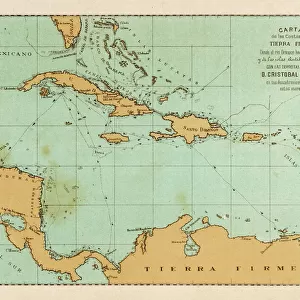
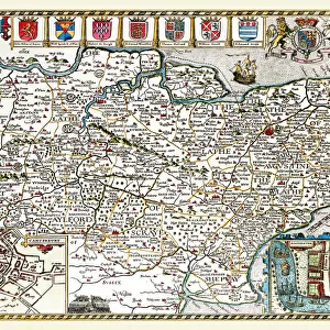
Old County Map of Hampshire 1836 by Thomas Moule

![]()
Wall Art and Photo Gifts from MapSeeker
Old County Map of Hampshire 1836 by Thomas Moule
This is a fine decorative reproduction County Map of Hampshire from the First Edition series of Thomas Moule Maps, originally Published in 1836. The well-known series of County Maps which are known as Moules feature beautiful vignette views and were first published in separate sections for each county in 1830-32, they were then published in collected form in a two-volume work: The English Counties Delineated: or a Topographical Description of England: Illustrated by a Complete Series of County Maps by Thomas Moule: London: Published by George Virtue 1836
Welcome to the Mapseeker Image library and enter an historic gateway to one of the largest on-line collections of Historic Maps, Nostalgic Views, Vista's and Panorama's from a World gone by.
Media ID 20348058
© Mapseeker Publishing Ltd
County Map County Map Of England English County Map Historic Map Moule Map Old County Map Old English County Map Old Moule Map Thomas Moule Thomas Moule Map Hampshire
FEATURES IN THESE COLLECTIONS
> Arts
> Artists
> M
> Thomas Moule
> Europe
> United Kingdom
> England
> Hampshire
> Related Images
> Europe
> United Kingdom
> England
> Hampshire
> Well
> Europe
> United Kingdom
> England
> London
> Towns
> Welling
> Europe
> United Kingdom
> England
> Maps
> Europe
> United Kingdom
> England
> Wells
> Maps and Charts
> Early Maps
> Maps and Charts
> Related Images
> MapSeeker
> Maps from the British Isles
> England and Counties PORTFOLIO
EDITORS COMMENTS
This exquisite print showcases the "Old County Map of Hampshire 1836" by Thomas Moule, a renowned cartographer of his time. Originally published in 1836 as part of Moule's First Edition series, this decorative reproduction captures the beauty and historical significance of Hampshire. Moule's county maps are highly regarded for their intricate details and captivating vignette views. The map was initially released in separate sections for each county between 1830-32 before being compiled into a two-volume work titled "The English Counties Delineated: or a Topographical Description of England". This particular edition was published in London by George Virtue in 1836. As you explore this historic map, you'll be transported back to the early 19th century, gaining insight into the geographical layout and landmarks that defined Hampshire during that era. From its charming towns to its sprawling countryside, every corner is meticulously depicted with precision and artistry. Whether you're an avid collector of antique maps or simply appreciate the allure of history, this old county map is sure to captivate your imagination. Display it proudly on your wall as a testament to both Moule's craftsmanship and Hampshire's rich heritage.
MADE IN THE USA
Safe Shipping with 30 Day Money Back Guarantee
FREE PERSONALISATION*
We are proud to offer a range of customisation features including Personalised Captions, Color Filters and Picture Zoom Tools
SECURE PAYMENTS
We happily accept a wide range of payment options so you can pay for the things you need in the way that is most convenient for you
* Options may vary by product and licensing agreement. Zoomed Pictures can be adjusted in the Cart.