Home > Africa > Chad > Related Images
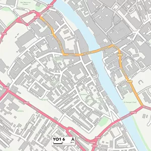
East Riding of Yorkshire YO16 4 Map

![]()
Wall Art and Photo Gifts from Map Marketing
East Riding of Yorkshire YO16 4 Map
Postcode Sector Map of East Riding of Yorkshire YO16 4
Media ID 19983146
Abbey Road Ashbourne Avenue Blenheim Road Borough Road Boundary Road Britannia Road Brookfield Close Brookland Road Burlington Gardens Cambridge Street Carlton Street Church Lane East Riding Of Yorkshire Easton Easton Road Enterprise Way Field Road Garden Court Gilbert Street Gordon Road Greenfield Road Harrington Road Havelock Street Hermitage Road Hill Street Jameson Road Kent Road Leys Road Main Street Meadow Road Melbourne Avenue Mere Lane Moor Lane Moorfield Road Nursery Grove Oxford Street Portland Place Quay Road Ramsey Close Ramsey Road Scarborough Road Scholars Way School Hill St Johns Avenue St Johns Close St Johns Walk St Martins Drive St Thomas Road Station Road Swindon Street Temple Lane Thompson Street Thornton Grove Thornton Road Toft Lane Victory Way Wayside Road Well Lane Wentworth Road West Hill Westbourne Avenue Westgate Wright Close Boynton Butchers Row
FEATURES IN THESE COLLECTIONS
> Africa
> Chad
> Related Images
> Animals
> Insects
> Related Images
> Arts
> Artists
> A
> John Andrew
> Arts
> Artists
> F
> John Field
> Arts
> Artists
> G
> John Gilbert
> Arts
> Artists
> H
> John Hillers
> Arts
> Artists
> H
> John Hills
> Arts
> Artists
> H
> Thomas Hill
> Arts
> Artists
> M
> John Martin
> Asia
> Turkey
> Related Images
> Map Marketing
> Postcode Sector Maps
> YO - York
MADE IN THE USA
Safe Shipping with 30 Day Money Back Guarantee
FREE PERSONALISATION*
We are proud to offer a range of customisation features including Personalised Captions, Color Filters and Picture Zoom Tools
SECURE PAYMENTS
We happily accept a wide range of payment options so you can pay for the things you need in the way that is most convenient for you
* Options may vary by product and licensing agreement. Zoomed Pictures can be adjusted in the Cart.