Home > Animals > Mammals > Muridae > Western Mouse
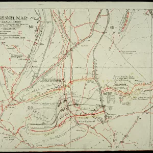
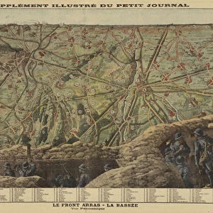
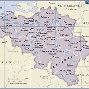
The Western Front battleground - map of August 1914

![]()
Wall Art and Photo Gifts from Mary Evans Picture Library
The Western Front battleground - map of August 1914
WW1 - The Western Front battleground - map of August 1914 Date: 1914
Mary Evans Picture Library makes available wonderful images created for people to enjoy over the centuries
Media ID 23095088
© Illustrated London News Ltd/Mary Evans
Advance Battleground Chart Forts Holland Lines Netherlands Overview Plan
FEATURES IN THESE COLLECTIONS
> Animals
> Mammals
> Muridae
> Western Mouse
> Europe
> Belgium
> Related Images
> Europe
> Netherlands
> Maps
> Europe
> Netherlands
> Posters
> Europe
> Netherlands
> Related Images
> Europe
> Related Images
> Mary Evans Prints Online
> New Images August 2021
EDITORS COMMENTS
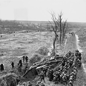
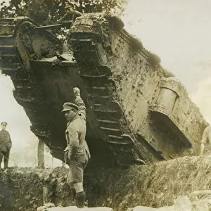
This evocative map, dating back to August 1914, provides a hauntingly detailed overview of the Western Front battleground during the early stages of the First World War. The intricate chart depicts the complex network of lines and fortifications that marked the border between Germany, France, Belgium, and Holland, as the forces of these nations prepared for the cataclysmic clash that would come to be known as the Great War. The Western Front, stretching from the North Sea to the Swiss border, was the primary theatre of war for the majority of the conflict. The map reveals the strategic positions of key fortifications, such as the heavily fortified German border forts, and the strategic heights of the Ardennes Forest, which were hotly contested throughout the war. The German advance into Belgium, which began on August 4, 1914, is clearly marked on the map, as the invading forces pushed towards the major cities of Liège, Namur, and Antwerp. The map also highlights the initial positions of the French and British forces, who rallied to defend their territories against the German onslaught. As the map reveals, the opening months of the war saw a stalemate, with both sides digging in and constructing extensive trench systems that would come to define the Western Front for the next four years. The map serves as a poignant reminder of the vast scale and complexity of the conflict, and the sacrifices made by millions of soldiers and civilians during the darkest days of the 20th century.
MADE IN THE USA
Safe Shipping with 30 Day Money Back Guarantee
FREE PERSONALISATION*
We are proud to offer a range of customisation features including Personalised Captions, Color Filters and Picture Zoom Tools
SECURE PAYMENTS
We happily accept a wide range of payment options so you can pay for the things you need in the way that is most convenient for you
* Options may vary by product and licensing agreement. Zoomed Pictures can be adjusted in the Cart.