Home > Europe > United Kingdom > England > London > Boroughs > Wandsworth
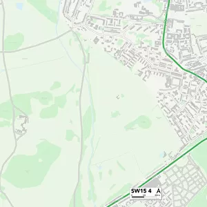
Wandsworth SW18 1 Map

![]()
Wall Art and Photo Gifts from Map Marketing
Wandsworth SW18 1 Map
Postcode Sector Map of Wandsworth SW18 1
Media ID 19982032
Adelaide Road Alma Road Bartholomew Close Bridgend Road Chesterton Close Church Row Cromford Road Dalby Road Enterprise Way Fairfield Drive Fairfield Street Frogmore Fullerton Road Garrick Close Juniper Drive Melrose Road Northfields Shoreham Close Smugglers Way Southfields Road The Causeway Viewfield Road Wandsworth West Hill West Hill Road
FEATURES IN THESE COLLECTIONS
> Animals
> Mammals
> Muridae
> Plains Mouse
> Asia
> Lebanon
> Related Images
> Europe
> United Kingdom
> England
> London
> Boroughs
> Wandsworth
> Europe
> United Kingdom
> Scotland
> Scottish Borders
> Melrose
> Europe
> United Kingdom
> Scotland
> West Lothian
> Bridgend
> Europe
> United Kingdom
> Wales
> Mid Glamorgan
> Bridgend
> Map Marketing
> Postcode Sector Maps
> SW - London SW
> Maps and Charts
> Related Images
MADE IN THE USA
Safe Shipping with 30 Day Money Back Guarantee
FREE PERSONALISATION*
We are proud to offer a range of customisation features including Personalised Captions, Color Filters and Picture Zoom Tools
SECURE PAYMENTS
We happily accept a wide range of payment options so you can pay for the things you need in the way that is most convenient for you
* Options may vary by product and licensing agreement. Zoomed Pictures can be adjusted in the Cart.