Home > Arts > Artists > H > Jodocus Hondius
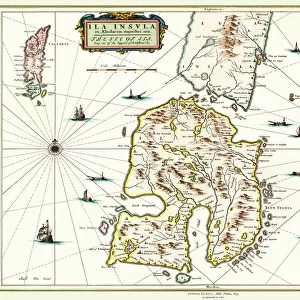
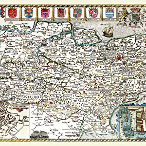
Old County Map of Wiltshire 1648 by Johan Blaeu from the Atlas Novus

![]()
Wall Art and Photo Gifts from MapSeeker
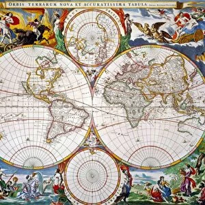
Old County Map of Wiltshire 1648 by Johan Blaeu from the Atlas Novus
This detailed and most attractive reproduction map of Wiltshire has been carefully art worked from a scan of an antique original. The famous firm of Dutch cartographers and publishers was established in the late 16th century by Willem Janszoon Blaeu in Amsterdam. Blaeu was a maker of globes and scientific instruments and purchased some of his early map plates from Jodocus Hondius. From this small beginning was to emerge one of the largest and most prolific map publishing houses of the seventeenth century
Welcome to the Mapseeker Image library and enter an historic gateway to one of the largest on-line collections of Historic Maps, Nostalgic Views, Vista's and Panorama's from a World gone by.
Media ID 20347693
Blaeu Blaeu Family Blaue Map County Map County Map Of England English County Map Historic Map Johan Blaeu Johan Blaeu Map Old Blaue Map Old County Map Old English County Map Wiltshire
FEATURES IN THESE COLLECTIONS
> Arts
> Artists
> B
> Willem Blaeu
> Arts
> Artists
> H
> Jodocus Hondius
> Arts
> Photorealistic artworks
> Detailed art pieces
> Masterful detailing in art
> Europe
> United Kingdom
> England
> Maps
> Europe
> United Kingdom
> England
> Wiltshire
> Related Images
> Maps and Charts
> Early Maps
> Maps and Charts
> Related Images
> Maps and Charts
> Willem Janszoon Blaeu
> MapSeeker
> Maps from the British Isles
> England and Counties PORTFOLIO
EDITORS COMMENTS
This beautifully crafted reproduction of the "Old County Map of Wiltshire 1648" by Johan Blaeu takes us on a journey back in time. Carefully art worked from an antique original, this map showcases the intricate details and artistic prowess that made Blaeu's maps so renowned. Johan Blaeu, a Dutch cartographer and publisher, established his firm in Amsterdam during the late 16th century. Initially known for his globes and scientific instruments, Blaeu expanded his repertoire to include map publishing. This small beginning would eventually lead to one of the largest and most prolific map publishing houses of the seventeenth century. The "Old County Map of Wiltshire" is a testament to Blaeu's dedication to accuracy and aesthetics. It provides a fascinating glimpse into England's past, with its depiction of towns, villages, rivers, forests, and other geographical features as they existed in 1648. Wiltshire itself holds historical significance as it was home to Stonehenge – an ancient monument that continues to captivate our imagination today. This map allows us to explore not only Wiltshire but also gain insights into how people perceived their surroundings centuries ago. Whether you are an avid history enthusiast or simply appreciate fine craftsmanship, this reproduction print is sure to be a treasured addition to your collection. Let it transport you back in time as you marvel at the beauty and intricacy captured within this historic piece of cartography.
MADE IN THE USA
Safe Shipping with 30 Day Money Back Guarantee
FREE PERSONALISATION*
We are proud to offer a range of customisation features including Personalised Captions, Color Filters and Picture Zoom Tools
SECURE PAYMENTS
We happily accept a wide range of payment options so you can pay for the things you need in the way that is most convenient for you
* Options may vary by product and licensing agreement. Zoomed Pictures can be adjusted in the Cart.