Home > Arts > Photorealistic artworks > Detailed art pieces > Masterful detailing in art
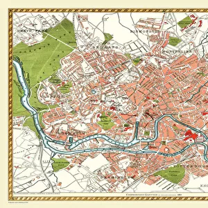
Old Map of Derby 1806 by Cole and Roper

![]()
Wall Art and Photo Gifts from MapSeeker
Old Map of Derby 1806 by Cole and Roper
An attractive and detailed early 19th century reproduction town plan of Derby 1805. First published by Cole and Roper as a finely engraved series of county maps and town plans which were initially issued in parts and then together as The British Atlas in 1810
Welcome to the Mapseeker Image library and enter an historic gateway to one of the largest on-line collections of Historic Maps, Nostalgic Views, Vista's and Panorama's from a World gone by.
Media ID 20348128
© Mapseeker Publishing Ltd
Cole And Roper Historic Map Old Town Plan Derby
FEATURES IN THESE COLLECTIONS
> Arts
> Photorealistic artworks
> Detailed art pieces
> Masterful detailing in art
> Maps and Charts
> Early Maps
> Maps and Charts
> Related Images
> MapSeeker
> British Town And City Plans
> English & Welsh PORTFOLIO
EDITORS COMMENTS
This print showcases an exquisite reproduction of the "Old Map of Derby 1806" by Cole and Roper. Dating back to the early 19th century, this town plan offers a fascinating glimpse into the historical landscape of Derby in 1805. With its intricate details and attractive design, this map allows us to explore the city's layout during a pivotal period in its history. Originally published as part of a meticulously engraved series of county maps and town plans by Cole and Roper, it later became part of their renowned work, The British Atlas, in 1810. The map provides an invaluable resource for historians, cartographers, or anyone with an interest in Derby's past. Its accuracy and attention to detail make it a valuable tool for studying urban development over time. As we examine this old town plan closely, we can trace the streets that have witnessed centuries of growth and change within Derby. From bustling marketplaces to quaint residential areas, every corner tells a story about the city's rich heritage. Whether you are researching local history or simply appreciate vintage cartography, this historic map is sure to captivate your imagination. It serves as a testament to Cole and Roper's dedication to preserving geographical knowledge while offering us a window into Derby's vibrant past.
MADE IN THE USA
Safe Shipping with 30 Day Money Back Guarantee
FREE PERSONALISATION*
We are proud to offer a range of customisation features including Personalised Captions, Color Filters and Picture Zoom Tools
SECURE PAYMENTS
We happily accept a wide range of payment options so you can pay for the things you need in the way that is most convenient for you
* Options may vary by product and licensing agreement. Zoomed Pictures can be adjusted in the Cart.