Home > Arts > Photorealistic artworks > Detailed art pieces > Masterful detailing in art
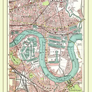
Old Street Map of Oxford Street, Holborn and Euston Road 1908

![]()
Wall Art and Photo Gifts from MapSeeker
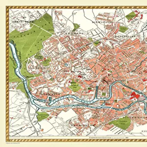
Old Street Map of Oxford Street, Holborn and Euston Road 1908
Detailed colour Street Plan of London from 1908 covering the area around Oxford Street, Holborn and Euston Road.The image has been remastered from Bartholomews Handy Atlas of London and Suburbs 1908
Welcome to the Mapseeker Image library and enter an historic gateway to one of the largest on-line collections of Historic Maps, Nostalgic Views, Vista's and Panorama's from a World gone by.
Media ID 20347781
© Mapseeker Publishing Ltd, Collins Bartholomew Ltd
London Map London Street Plan Map Of Central London Map Of London Old London Street Map Old Map Of London Central Street Map Of London Street Plan Euston Euston Road Holborn Oxford Street
FEATURES IN THESE COLLECTIONS
> Arts
> Photorealistic artworks
> Detailed art pieces
> Masterful detailing in art
> Maps and Charts
> Related Images
> MapSeeker
> British Town And City Plans
> English & Welsh PORTFOLIO
EDITORS COMMENTS
This beautifully remastered print takes us back in time to the bustling streets of London in 1908. Capturing a detailed color street plan, it focuses on the iconic area around Oxford Street, Holborn, and Euston Road. A true treasure for history enthusiasts and lovers of vintage maps, this image is sourced from Bartholomews Handy Atlas of London and Suburbs 1908. As we gaze upon this old street map, we are transported to an era when horse-drawn carriages roamed these roads instead of modern vehicles. The intricate details showcase the layout of buildings, parks, and landmarks that have stood the test of time. Oxford Street, known as one of London's premier shopping destinations even then, appears prominently on this map. Its vibrant atmosphere can almost be felt through the faded colors and delicate lines that define its path. Nearby Holborn and Euston Road also make their mark on this historical document. The craftsmanship behind this piece is evident as every inch has been carefully restored by John Bartholomew from Collins Bartholomew Mapseeker Publishing. It serves as a reminder not only of how much our cityscape has evolved but also how important it is to preserve our past for future generations. Whether you're a local resident or simply captivated by London's rich history, this old street map offers a glimpse into a bygone era – an opportunity to explore the streets as they once were over a century ago.
MADE IN THE USA
Safe Shipping with 30 Day Money Back Guarantee
FREE PERSONALISATION*
We are proud to offer a range of customisation features including Personalised Captions, Color Filters and Picture Zoom Tools
SECURE PAYMENTS
We happily accept a wide range of payment options so you can pay for the things you need in the way that is most convenient for you
* Options may vary by product and licensing agreement. Zoomed Pictures can be adjusted in the Cart.