Home > Asia > Japan > Maps
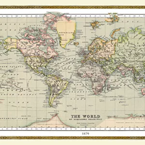
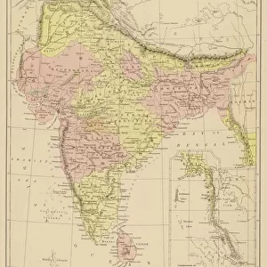
Old Map of the World 1875

![]()
Wall Art and Photo Gifts from MapSeeker
Old Map of the World 1875
THE WORLD THAT WAS 1875 - Britain under Disraeli buys the Suez Canal to protect the sea route to India. USA expands settlement into Oregon. Egyptian invasion of Ethiopia. Treaty between Japan and Russia settles territorial claims. StanleyAEs African expedition continues, suffering enormous hardships
Welcome to the Mapseeker Image library and enter an historic gateway to one of the largest on-line collections of Historic Maps, Nostalgic Views, Vista's and Panorama's from a World gone by.
Media ID 20347209
© Collins Bartholomew - Mapseeker Publishing Ltd
Map Of The World Old Map Of The World The World World Map
FEATURES IN THESE COLLECTIONS
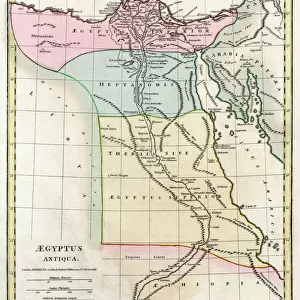
> Africa
> Ethiopia (Abyssinia)
> Related Images
> Africa
> Ethiopia
> Related Images
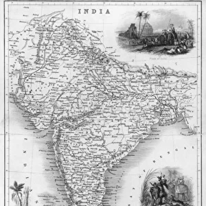
> Asia
> India
> Related Images
> Maps and Charts
> India
> MapSeeker
> Maps Showing the World
> Maps of The World by Year PORTFOLIO
EDITORS COMMENTS
This print takes us back in time to the year 1875, offering a glimpse into the world as it once was. The old map of the world displayed here is not just a mere representation of geographical boundaries; it tells stories of significant historical events that shaped nations and continents. In this particular snapshot, we witness Britain's strategic move under Prime Minister Disraeli, acquiring the Suez Canal to safeguard its vital sea route to India. Meanwhile, across the Atlantic Ocean, the United States expands its settlements into Oregon, marking another milestone in their westward expansion. The map also highlights an intriguing conflict between Egypt and Ethiopia through an invasion by Egyptian forces. This event serves as a reminder of past tensions and power struggles within Africa during that era. Amidst these geopolitical developments, we find a glimmer of hope for peace with Japan and Russia reaching a treaty that settles territorial claims between them. Such diplomatic agreements were crucial in maintaining stability amidst global rivalries. Lastly, Stanley's African expedition stands out prominently on this map - an arduous journey fraught with immense hardships but driven by curiosity and exploration. This vintage map print encapsulates not only geographical information but also offers valuable insights into political dynamics and human endeavors from over a century ago. It serves as both an educational tool and a nostalgic window into our shared history.
MADE IN THE USA
Safe Shipping with 30 Day Money Back Guarantee
FREE PERSONALISATION*
We are proud to offer a range of customisation features including Personalised Captions, Color Filters and Picture Zoom Tools
SECURE PAYMENTS
We happily accept a wide range of payment options so you can pay for the things you need in the way that is most convenient for you
* Options may vary by product and licensing agreement. Zoomed Pictures can be adjusted in the Cart.