Home > Europe > France > Paris > Maps
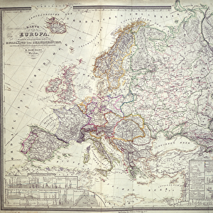
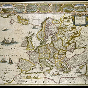
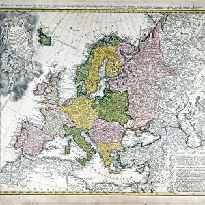
Map of Europe, published in 1700, Paris (colour engraving)
")
![]()
Wall Art and Photo Gifts from Fine Art Finder
Map of Europe, published in 1700, Paris (colour engraving)
REV345801 Map of Europe, published in 1700, Paris (colour engraving) by Delisle, Guillaume (1675-1726) (after); Private Collection; (add.info.: Guillaume de L Isle, geographe du Roi de France; geographer of King of France; ); French, out of copyright
Media ID 22947660
© Bridgeman Images
Continent Geographical Mapping
FEATURES IN THESE COLLECTIONS
> Europe
> France
> Paris
> Maps
> Fine Art Finder
> Artists
> French School
> Fine Art Finder
> Artists
> Guillaume (after) Delisle
> Fine Art Finder
> Maps (celestial & Terrestrial)
> Maps and Charts
> Related Images
EDITORS COMMENTS
This print showcases a remarkable piece of history - a Map of Europe, published in 1700, Paris. Created by the renowned French geographer Guillaume de L'Isle, who served as the official cartographer to the King of France, this exquisite colour engraving offers us a glimpse into the geographical knowledge and mapping techniques prevalent during that era. The map itself is an intricate masterpiece, meticulously detailing the European continent with precision and accuracy. It provides valuable insights into the political boundaries, topography, and even cultural nuances of various regions across Europe at that time. As we delve into its intricacies, we can almost imagine ourselves embarking on a journey through time. The vibrant colours used in this engraving add depth and richness to each country's distinct features. The delicate lines etched onto paper reveal Guillaume de L'Isle's mastery in capturing geographic information and his dedication to presenting it aesthetically. Preserved within a private collection today, this historical artifact reminds us of how cartography has evolved over centuries while also serving as a testament to human curiosity about our world. Whether you are an avid historian or simply fascinated by maps and geography, this enchanting print will undoubtedly transport you back to 18th-century Europe – an era filled with exploration and discovery.
MADE IN THE USA
Safe Shipping with 30 Day Money Back Guarantee
FREE PERSONALISATION*
We are proud to offer a range of customisation features including Personalised Captions, Color Filters and Picture Zoom Tools
SECURE PAYMENTS
We happily accept a wide range of payment options so you can pay for the things you need in the way that is most convenient for you
* Options may vary by product and licensing agreement. Zoomed Pictures can be adjusted in the Cart.